Earthquakes are one of the most powerful natural phenomena on Earth. They are sudden, violent shakings of the ground caused by the abrupt release of energy in the Earth's crust, typically resulting from the movement of tectonic plates. The quake sends energetic waves through the earth, causing the solid earth to ripple like a fabric. While often destructive, causing immense damage to infrastructure and sometimes triggering tsunamis, they are also a fundamental part of our planet's dynamic geological processes. Earthquakes play a crucial role in shaping Earth's landscapes by uplifting mountains and creating valleys. However, to understand their role in shaping the surface of our planet, we must first determine when they occurred.
A new study from Physical Research Laboratory (PRL), Ahmedabad, CSIR-National Geophysical Research Institute (NGRI), Indian Institute of Technology (IIT) Gandhinagar, Homi Bhabha National Institute, Academy of Scientific and Innovative Research (AcSIR), and the Institute for Plasma Research (IPR), Gandhinagar, have come up with an innovative method to date powerful earthquakes. The study utilises sand found in geological features known as sand dikes to determine when an earthquake occurred.
Did You Know? The December 2004 earthquake that struck Sumatra, Indonesia, known in the scientific community as the Sumatra–Andaman earthquake, was caused by a rupture along the fault between the Burma plate and the Indian plate. |
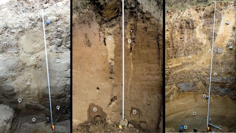
During a powerful earthquake, intense ground shaking can cause water-saturated, loose sandy sediments to temporarily lose their strength and behave like a fluid, a process known as liquefaction. This fluid-like mixture of sand and water, often located beneath a more solid confining layer, builds up immense pressure. When this pressure becomes sufficiently high, it can fracture the overlying sediment layers, resulting in the formation of cracks and fissures. The liquefied sand and water then surge upwards through open cracks, driven by the pressure difference. As the earthquake shaking subsides, the injected material solidifies, becoming trapped within the cracks and forming the distinctive vertical or near-vertical geological features known as sand dikes.
For geologists, these sand dikes provide clues to the contents of the Earth’s interior and hold crucial insights into understanding our planet's turbulent history. The new study now presents a method for predicting the age of the quake that caused the sand dike using a phenomenon known as luminescence dating.
Luminescence dating is a geological technique used to determine when certain minerals, like quartz and feldspar, were last exposed to sunlight or intense heat. These minerals naturally accumulate energy from ambient radiation, like gamma rays and x-rays, in their environment over time, trapping it within their crystal structure. This stored energy is often referred to as a luminescence signal. When these minerals are stimulated with light (Optically Stimulated Luminescence, or OSL) or heat (Thermoluminescence, or TL), the trapped energy is released as a faint glow. The age of the sediment, which is proportional to the energy stored, can then be calculated by measuring this glow.
During the formation of a sand dike, as the thick, sandy fluid rapidly moves through narrow channels, the individual sand grains rub against each other with incredible force. This friction creates a significant amount of heat. The researchers' theoretical calculations showed that this viscous heating could raise the temperature of the injected sediments to a scorching 350 to 450 degrees Celsius, or even higher, for a brief period. They hypothesised that the intense heat was enough to reset the luminescence signal within the sand grains. This process, termed viscous heating, effectively wipes clean the geological clock stored in the minerals and restarts the accumulation process.
To confirm their theoretical predictions, the scientists conducted thermoluminescence sensitivity (TLS) measurements on quartz grains from the sand dikes. They observed that the sensitivity of these grains increased significantly above 350-400°C, a clear indicator that the dike sediments had indeed experienced heating in this range during their formation. This experimental evidence strongly supported the idea that viscous heating was sufficient to reset the luminescence signal. By then applying optically stimulated luminescence (OSL) dating to these reset sand grains, they could directly determine the age of the sand dikes. The novel approach enabled them to pinpoint the timing of three major seismic events in the North East region of India: approximately 300 years ago, 1,000 years ago, and more than 1,500 years ago.
This research significantly advances our ability to reconstruct past earthquake histories. Conventional methods, such as radiocarbon dating, can be limited by the scarcity of well-preserved organic material or contamination from human activity. The new method provides a more direct and precise means of dating the seismic event itself. While the study found that the OSL ages of the sand dikes were stratigraphically consistent with the surrounding sediments and even with previously published radiocarbon ages, the researchers also noted some areas for future refinement. For instance, wider or shorter dikes might experience less complete heating, suggesting that sampling from the central, narrower parts of dikes would yield the most reliable results.
The work provides a new tool for paleoseismology, the study of ancient earthquakes. By directly dating the sand dikes, researchers can build more accurate chronologies of past seismic events. This improved understanding of when and how often large earthquakes have occurred in a region is crucial for assessing seismic hazards, refining building codes, and developing better preparedness strategies for communities living in earthquake-prone areas. Moreover, it provides us a glimpse of the immense events that shaped the Earth.
This article was written with the help of generative AI and edited by an editor at Research Matters.


