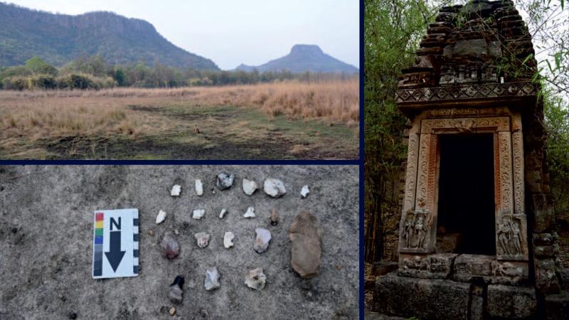
(Top left)Bandhavgarh (left) and Bandheini (right) from Charadhara meadow. (Bottom left) Scatter of prehistoric stone tools and debitage from Sita mandap area. (Right) Sheshashayi Vishnu. Image Credit: Authors, https://doi.org/10.1177/09596836251358726
Around 73,000 and 55,000 years ago, modern humans are believed to have first set foot in the Indian subcontinent. Over time, they gradually consolidated and evolved, establishing one of the oldest civilisations in the ancient world. Much of this ancient human story has been pieced together by archaeologists and researchers through the study of monumental ruins, geological artefacts and ancient texts. However, much more of the story of this land, including the rise and fall of its forests, the success and failure of its farmers, and the stability of its empires, has been stamped into the mud, pollen, and microscopic algae buried beneath its surface.
Now, a new study by researchers from Birbal Sahni Institute of Palaeosciences (BSIP), Agharkar Research Institute (ARI), Academy of Scientific and Innovative Research (AcSIR) and Ashoka University has studied the layers of the soil to uncover the story of geographical and civilisational changes in India going back over 2500 years.
This is the story of Central India, specifically the region around Bandhavgarh National Park and Tiger Reserve, told through the diatoms and pollen buried deep beneath a swamp. For 2,600 years, the climate of the Indian Summer Monsoon (ISM) has been the principal architect of this landscape, shaping everything from the forests to the rise and fall of human settlements. The researchers studied a 60 cm sediment core extracted from the Chakradhara swamp within Bandhavgarh National Park. They then used a multi-proxy approach, analysing mineral magnetism, pollen, carbon/nitrogen (C/N) ratios, and microscopic organisms called diatoms. The study uncovered five distinct chapters in this climate-driven history.
Phase I: The Wet Dawn and the First Farmers (572–345 BCE)
The story begins in the early 6th century BCE, a time of moderate to high monsoon activity. The climate was warm and wet, and the landscape consisted of an open, mixed tropical deciduous forest. This period coincided with the emergence of hunter-gatherers and early agriculturists, as evidenced by stone tools and early cereal pollen. Researchers found a high concentration of silt and clay in the sediment core from this period. This indicates a significant influx of material flowing in from the surrounding hills, likely driven by heavy monsoon rainfall.
The microscopic diatoms confirm this picture, with a dominance of planktonic diatoms, which are species that float in deep, turbulent, nutrient-rich water. Crucially, the pollen record reveals the presence of Cerealia pollen, the signature of domesticated grains. Its presence indicates that hunter-gatherers and early agriculturists were emerging in the region during this period. This wet period coincided with the global Roman Warm Period (RWP), a period of unusually warm weather in Europe and the North Atlantic that lasted roughly from 250 BC to AD 400. The period also saw the rise of the Mauryan Empire in India, which led to a surge in agricultural production and socio-economic prosperity across the subcontinent.
Phase II: The Agricultural Peak and Early Construction (345–199 BCE)
As the Mauryas and Sungas ruled northern and central India, the Bandhavgarh region experienced a high-energy depositional environment characterised by strong water flow, including rapidly moving streams, waves, and strong currents. These waters can transport and deposit coarse-grained sediments such as sand, gravel, and even boulders while preventing the accumulation of fine-grained mud and silt. The sediment record shows an influx of coarser materials, likely associated with intense erosion and runoff. The higher erosion, the researchers believe, may be linked to early construction projects in the catchment.
Despite the broader climate remaining warm and wet, the local wetland environment during this period showed signs of being stressed. Diatoms found from this time exhibit highly uneven distribution and variability in features, characteristics, and populations across the geographic area, a phenomenon known as high spatial heterogeneity, indicating an exacting environment. While some areas were eutrophic (nutrient-rich), the dominance of acidic, oligotrophic organisms, like the Eunotia species, suggests that much of the basin was experiencing acidic, mineral-poor conditions. This period also marks the earliest instances of human construction, with the creation of artificial rock-cut caves used as shelters by temporary populations or travellers passing through the area.
Phase III: The Sal Forest Bloom (199 BCE–470 CE)
For about 350 years, the climate stabilised into a warm, moist phase, reflecting abundant, favourable monsoon rains. The vegetation thrived, dominated by tropical deciduous Sal forests (Shorea robusta). Indications of a tree-savannah vegetation, a mixed woodland-grassland habitat with trees sufficiently widely spaced, suggests the forests were relatively open in structure.
The diatoms confirm the return to abundant moisture, with a shift back to open-water planktonic species, indicating deep, stable water levels. This era, spanning the rule of the Kushanas, Maghas, and Guptas dynasties, was a time of continued construction and the flourishing of a forest ecosystem under favourable climatic conditions.
Phase IV: The Age of Architecture and Drought (470–1560 CE)
The stable, wet climate gave way to increasing fluctuations and instability, coinciding with the global Dark Age Cold Period (DACP). The climate became drier, and the pollen record shows a substantial decline in arboreal pollen (AP), which are the pollen from trees, and an increase in dry-deciduous components.
This period is defined by the Kalachuri dynasty, who left a lasting architectural and cultural legacy, including temples, sculptures, and gateways. To combat the DACP-era water scarcity, the Kalachuris undertook systematic tree clearance on the plateaus and hills, marking the onset of significant landscape alteration. They also constructed reservoirs, such as Rani Talab, to transform natural water bodies into artificial storage, a crucial strategy for managing water resources during periods of reduced rainfall.
Phase V: From Village to Reserve (1560 CE–Present)
The final phase saw the region transition from a major travel route to a settled agricultural landscape under the Baghels, Mughals, and British. The early part of this phase was characterised by fine-grained sedimentation (silt and clay), suggesting significant siltation. This is likely due to the overflow of water from rivers and streams, spilling into surrounding areas or deposition in a floodplain where slow-moving floodwaters deposit the fine sediment.
The diatoms show a final, dramatic shift: a decline in aquatic species and a resurgence of acidic/oligotrophic species, alongside the complete disappearance of planktonic diatoms, indicating a drier climate in the later part of the period. The story of human impact culminates with the establishment of Bandhavgarh as a National Park (1968) and a Tiger Reserve (1993), a significant conservation milestone. Instrumental data from the past century, however, offers a hopeful note, revealing a trend of increasing rainfall since 1971, which may be aiding the recovery of the forest ecosystems that were once cleared.
The 2,600-year history of Bandhavgarh is a microcosm of the enduring relationship between climate and culture in the Indian subcontinent. It shows that the fate of civilisations, from the emergence of early farmers to the architectural consolidation of medieval kingdoms, was inextricably linked to the stability and variability of the Indian Summer Monsoon. This research underscores that to understand the trajectory of human societies in one of the world's oldest civilisations, we must first understand the rhythm of the climate that shaped it.
The article's title was edited to reflect the views of the researchers accurately.
