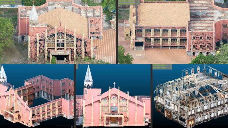
Image: UAV point cloud model for external surfaces (Top) and TCRP point cloud model for external and internal surfaces (Bottom) Credit: Authors, https://doi.org/10.1061/JSUED2.SUENG-1568
India is a land with a vast architectural history spanning millennia. From the rock-cut Vihāras of the Mauryan Empire to the polychromatic Gopurams of the Dravidians and the luminous marble shells of Mughal mausoleums, such as the Taj Mahal, this land has produced some of the most diverse forms of architecture, each with its own characteristic style. But even these monumental creations are not immune to the slow and relentless march of time. Look closely, and one can see where the monsoon rains have polished the stone, where the wind has scoured the intricate carvings, and where the persistent, creeping mould has begun to soften the vibrant colours. To ensure future generations can enjoy these architectural wonders, they must be documented in all their intricate glory.
A team of researchers from the Indian Institute of Technology (IIT) Bombay have now developed a method to create perfect digital twins of these irreplaceable landmarks, capturing every minute detail, every weathered stone, and every hidden corner. Traditionally, laser scanning methods are used, which offer high accuracy but is often prohibitively expensive and time-consuming, especially for large structures or those with complex interiors. The new study introduces a cost-effective and highly accurate method for creating detailed three-dimensional maps of heritage structures using Unmanned Aerial Vehicles (UAVs), also known as drones, and terrestrial photogrammetry, a technique that utilises overlapping 2D photographs to create 3D models and measurements.
Did You Know? Photogrammetry, the science of making measurements from photographs, dates back to the mid-19th century, with early applications in mapping and architecture. |
To test their method, they focused on a beautiful heritage church in Solapur, Maharashtra, India. The goal was to create a comprehensive 3D model that captured both the exterior grandeur and the fragile yet exquisite interior details of the church. The process began with extensive data collection. Drones were deployed to fly systematically around and over the church, capturing thousands of overlapping aerial photographs of its exterior. These aerial shots provided a bird's-eye view of the structure reaching high, inaccessible areas.
Simultaneously, they used ground-based cameras to take countless close-up photos of the church's interior, its facades, and other detailed elements that drones might miss or struggle to capture with sufficient detail. The researchers planned their camera positions and flight paths to ensure every part of the structure was photographed multiple times from different angles.
Once the vast collection of images was gathered, they employed photogrammetry to recreate the 3D model. The photos were first fed into software, such as WebODM (OpenDroneMap), which uses algorithms to analyse the images. By identifying common points across multiple photographs taken from different perspectives, the software can precisely calculate the 3D coordinates of those points in space. This process generates what's called a point cloud, a massive collection of millions, or even billions, of individual data points that together form a highly accurate digital representation of the physical structure.
The next step was to integrate the data from the two different sources, the drone-generated aerial point cloud and the ground-based terrestrial point cloud. The researchers used an algorithm called Iterative Closest Point (ICP) to register or align these two point clouds perfectly. This ensures that the exterior model from the drone seamlessly merges with the interior and ground-level details from the terrestrial cameras, creating a single, unified, and incredibly detailed 3D model of the entire church.
Finally, to make this rich data accessible and usable, the combined 3D model was converted into a GLTF (Graphics Language Transmission Format) model. GLTF is an open-standard format specifically designed for efficient transmission and loading of 3D scenes and models on the web. This allowed the researchers to create a web-based platform where anyone could virtually explore the church, zoom in on details, and even take measurements, all from a standard web browser.
Using a combination of low-cost drones and readily available cameras makes this new method far more affordable and accessible, particularly for developing nations with rich heritage but limited budgets. Furthermore, by integrating both aerial and terrestrial data, the researchers achieved a level of comprehensiveness and accuracy that single methods often struggle to match. It provides a complete picture, inside and out, which is vital for holistic preservation efforts.
The research provides an invaluable tool for creating precise digital archives, which are essential for monitoring decay, planning restoration work, and even reconstructing structures if they are ever damaged. For education and tourism, these interactive 3D models can bring history to life, enabling people worldwide to virtually visit and learn about cultural landmarks. By making advanced 3D mapping more affordable and accessible, this research empowers communities globally to become digital guardians of their own history, ensuring that the stories etched in stone and timber endure for generations to come.
